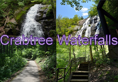
We had done hike on Crabtree Waterfalls on 15th May 2016 . It is located in Virginia State. These are the highest waterfalls in Virgina.
Hike Location
Name: Crabtree Waterfalls
Distance: 110 miles from Richmond(approx)
Total hiking distance: 3.8 miles(approx).
Altitude: 1380 ft.
Hike Members: Me and my wife.
Hiking Experience: We started from home around 9:30 am on a fine Saturday. The weather was very good. Around one and hour later there was a ghat road traversing the mountain. We rode for almost half an hour on the ghat road. We reached the parking around 11:50 am. Being good climate and great falls the place is flooded with cars and parked the car on side of the road. Enjoyed the chilly winds. Started the hike around 11:55 am. The trail started with wooden bridge with trees on both sides. the bridge is wide. The trail got steeper as we reached wooden steps. We could hear thundering roars of waterfall but couldn't see the falls yet. On one side we could see huge mountain and other side exposure to the valley. With such a wonderful environment felt eager to see the falls. The steps are all covered with mud and slippery as it rained here yesterday. We encountered lot of fellow hikers along the hike along with their pets.
We saw the base of the falls. The water was splashing making sound as they fall on the rocks. The rocks are covered with moss. It was a great delight for the eyes. We could feel very cold weather due to chilly winds. With chill weather, light water droplets and splashing sound it was a great experience. we took pictures at the base of the falls and hiked further to view the middle level of the falls. The trail became little steeper and there are steps along the trail. We hiked further with falls to our left all along the trail. The falls were amazing at the middle level and there was a view point at the middle level to get a good glimpse of the falls.
We hiked further. Around 12:50 pm we had lunch beside the falls. We started hike again around 1:00 pm. There is huge boulder on right side. We crossed it and went ahead. There was a cave and we went through the cave and continued on the trail and reached the top of the mountain , start point of the falls, around 2:00 pm. The view was awesome from the top and it was very cold. We started descent around 2:20 pm. Same path through which we came up. Whole path is slippery and covered with mud. We reached the parking around 3:40 pm. Reached home by 6:00 pm. Of all treks this trek is more memorable and wonderful as this was the first trek with my better half. All is Well.


